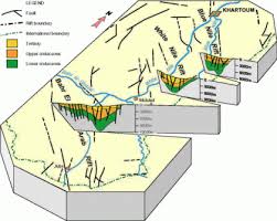

The White Nile rift basin is longitudinal in shape and extends in a NW-SE direction. It is about 520 km in length and 400 km in width at Umm Ruwaba trough and 360 km in width in the White Nile trough. The fine deltaic deposits of Khor Abu Habil were deposited in the Nuba deltaCoarse sediments were deposited in the deeper parts of the troughs, and are encountered at various depth intervals from the surface to 600 m). The sediments deposited by Khor Abu Habil are characterised by the absence of volcanic clasts and the high percentage of coarse material in the margin of the fault zones at a depth of 200-300 m. The high percentage of fines and clays in the fan area and the presence of salt layers (evaporites) in the fan delta area.
There are several published descriptions of the sediment types in the Umm Ruwaba graben and these appear to vary with the well location. Most workers suggested that the Umm Ruwaba sediments are fluviatile and lacustrine suggested that the sediments were laid down in a series of land deltas with layers of very fine sand (possibly aeolian), and layers of gypsum and evaporates.
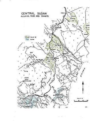
Detailed interpretation of ERTS imagery for Khor Abu Habil showed the presence of palaeochannels extending from Umm Ruwaba eastwards with main tributaries towards the north east to Kosti and southeast to Keri Kera. The Abu Habil fan deposits are mainly clays and very fine silts. Similar deposits are known in most of the internal drainage systems of today's major wadies, such as the River Gash, Wadi El Kuu, Wadi Nyala, Wadi Bulbul and Wadi Shellang.
Thick extensive carbonate deposits are reported at Khartoum, White Nile near Dueim and Gezira.
The Nuba Lakes
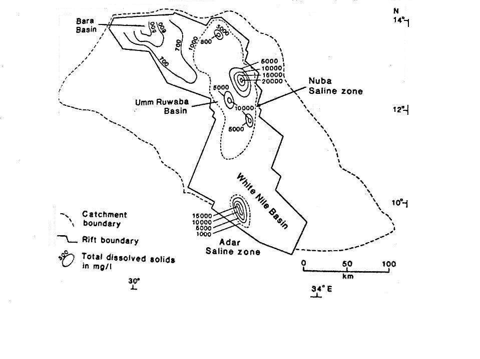
The Nuba buried saline lakes extend from near Abu Habil in the north, to W. Adar in the south These were formed by the palaeo Abu Habil and wadi Adar drainage system. Today the mean annual flow of Abu Habil is 100 million m3, while that of wadi Adar is estimated to be 1.5 to 2.0x10⁹ m3. ERTS.1 satellite imagery, shows a large alluvial fan on the left bank between Kosti and Keri Kera with numerous small meandering distributaries which has been formed by Khor Abu Habil. The trough which occupies the central part of the White Nile Rift is the lowest water level contour (320m) in the central part of Sudan. This indicates that the Nuba lakes received water from the Gezira and Sudd lakes at one time or another during its depositional history. This also seems likely as the very slow deposition rates of Abu Habil compared to the White and Blue Niles system, always kept the Nuba lakes area at a lower depositional level.
Salinity parameters and saturation indices indicates that the area enclosed by the iso-salinity line of 1000 mg l-1, defines the margins of the saline lake zone. The high salinity zones within this saline zone, represent four smaller separate buried saline lakes. Each of these lakes occupied one of the troughs within the rift structures of the Umm Ruwaba graben (Abu Habil saline zone in Abu Habil trough, East and West Er Rawat saline zones in East and West er Rawat troughs). Another saline water body along W. Adar, in the Adar trough, with salinities higher than 10,000 mg l-1, indicates the presence of another saline lake in this trough. The presence of high sulphate concentrations in the Nuba lakes shows that it had similar depositional environment to that at the Sudd lake.
The late Pleistocene evaporites near Esh Shawal indicated that the absence of clastic components, the well ordered crystalline structure and uniform altitude of the evaporites, and their radiocarbon ages all suggest prolonged late Pleistocene evaporation of an extensive body of still, saline water along what is now the White Nile flood plain. The rough accordance in age between these White Nile evaporites and those that crop out in the Blue Nile south of Khartoum may indicate prolonged aridity and an absence of outflowing drainage in the Gezira at this time. The radiocarbon ages are more than 40,000 years.