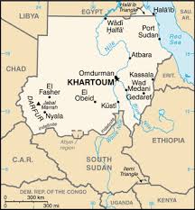
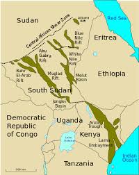
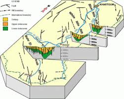
The deep lineaments and shear patterns of Sudan follow two main directions (Fig. 1): NNW (Red Sea trend) and ENE (Gulf of Aden trend) (Salama, 1985a & b; Schull, 1988). Pre Cambrian mobile belts trend NE and NW (Vail, 1978; Almond, 1982; Ahmed, 1982). Palaeozoic (?) sediments occupy NE-SW aligned grabens (Salama, 1985a). Mesozoic continental sediments with NW palaeotrends were deposited in two major depressions also aligned NW (Salama 1985a). Three phases of rifting are recognized (Brown and Fairhead, 1983; Salama, 1985a and (1993); Schull, 1988). The first phase was thought to have begun in the Jurassic (?) - lower Cretaceous (130-160Ma). No volcanic activity is associated with this rift phase. The second phase which occured during the Turonian-Late Senonian (Upper Cretaceous) was associated with minor volcanic activity. The third rift phase began in the late Eocene-Oligocene, during which scattered volcanism occured (Vail, 1978). This was followed by an intracratonic sag phase of very gentle subsidence accompanied by little or no faulting. The sag period was associated with extensive volcanism parallel to Zalingei folded Belt (Salama, 1985b). The effect of rifting caused the development of a complicated system of grabens having a predominant NNW direction formed by dip-slip faulting associated with rotated fault blocks, drape folds and reverse drage folds (Schull, 1988). The Sudanese Cainozoic rift system, forms the largest rift system in Africa, it extends from the eastern borders of Sudan with Ethiopia to the western borders with Central African Republic and Chad. It includes from west to east; Bahr El Arab Rift, Wadi El Kuu rift, White Nile Rift, Blue Nile Rift and River Atbara rift (Fig. 2). The thick Jurrassic (?) - Cretaceous and Tertiary sediments filling the deep grabens (Schull 1988) were eroded from the following elevated blocks; Jebel Marra, Nuba mountains, Ingessena Hills, Darfur Dome and the Nile Congo divide (Salama 1985a & 1987; Schull 1988).